Wednesday, May 9, 2012

Current Weather Conditions for Wednesday May 9th, 2012

Current Conditions
Temperature - 62.7 degrees Fahrenheit
Dew point - 37 degrees Fahrenheit
Relative humidity - 37%
Wind direction - WNW
Wind speed - 7 mph, gusting up 10 mph
Barometric pressure - 1029.83 degrees Fahrenheit
Cloud cover - clear


Looking at the eastern seaboard on the surface map, I would say my prediction that of intensified storms as the series of high pressure systems moved is correct. As for Eau Claire, well looks like we're going to a have a break in the rainy weather. The series of high pressure systems in the central United States will be keeping conditions mostly clear and sunny for the next couple days.

Tuesday, May 8, 2012

Current Weather Conditions for Tuesday May 8th, 2012

Current Conditions
Temperature - 54.4 degrees Fahrenheit
Dew point - 46 degrees Fahrenheit
Relative humidity - 72%
Wind direction - WNW (http://hint.fm/wind/index.html)
Wind speed - inconsistent, calm but gusting up to 9 mph.
Barometric pressure - 1029.76 g/kg
Cloud cover - overcast (stratocumulus, stratus, altocumulus, cirrocumulus)


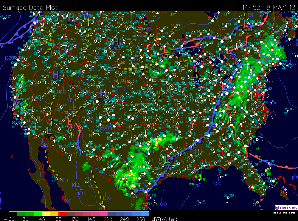
Currently in Eau Claire the low pressure system in the area is causing these overcast conditions. As you may have noticed in the cloud cover summary there is a wide variety of cloud types. What this is indicating is rising warm airmass due to a cold front wedging underneath it. If you direct your attention to the surface map above, take a look at the dry line running through Minnesota and northern Wisconsin. As we move into this afternoon between the 1pm to 4pm range is highly likely that we will experience a thunderstorm due to convective lifting on that stationary front in conjunction with the dry line.


As is evident in the 300 millibar map above, the jet stream is dipping down into the Midwest. In affect this means the continental polar air mass is bringing about  cooler temperatures today than we have had recently. This is allowing for the cold front to cause convective lifting on the stationary front north of Wisconsin, as I referenced earlier. However I want to talk more about what the jet-stream is going to look like tomorrow and more importantly what it the affect will be. The western U.S., specifically west of the Rockies, is very hot to day. As the series of high pressure systems in the Western U.S. move from west to east, the Midwest will in affect experience a rise in temperatures throughout the week. More interestingly though, I expect that storms on the Eastern seaboard will be intensified as this occurs. Once I see exactly how this storm tracks I will fill you in, but more on that tomorrow!

Sunday, May 6, 2012

Current Weather Conditions for Sunday May 6th, 2012

Current Conditions
Temperature - 56 degrees Fahrenheit
Dew point - 55 degrees Fahrenheit
Relative Humidity - 95%
Wind direction - N (http://hint.fm/wind/index.html)
Wind speed - 1 mph
Barometric pressure - 1029.85 g'kg
Cloud cover - overcast (stratus)

Pretty interesting weekend for storms in Eau Claire. I have to say we received more rain than I had anticipated we would. Then again it can difficult to make accurate predictions when you are dealing with stationary fronts and convective lifting.


Although most of our precipitation occurred on Monday and Wednesday, we did have a few short intense storms Thursday through today.


It is interesting to look at the barometric pressure records for this week because you can see when those short intense storms occurred. They occurring when the barometric pressure briefly and suddenly drops.


Not so fast though, we aren't quite ready to stop keeping track of the precipitation accumulated this week. The occluded front front, which is to the west of us currently, could likely produce some lighter showers as it moves through Wisconsin tonight.

Friday, May 4, 2012

Current Weather Conditons for Friday May 4th (Star Wars Day!), 2012

Current Conditions
Temperature - 69.9 degrees Fahrenheit
Dew point - 49 degrees Fahrenheit
Relative humidity - 49%
Wind direction - E (http://hint.fm/wind/index.html)
Wind speed - 4 mph, gusting up 11 mph.
Barometric pressure - 1029.86 g/kg
Cloud cover - clear

Unless you live under a rock or don't live in Eau Claire, I am sure you noticed the beautiful colors in that storm last night. Be sure to check out the photos section in my blog for some pictures that I took of the storm.


As for today the cold front that caused all that convective lifting in the Eau Claire area has progressed southward to the border of Wisconsin and Illinois. If you look to the West of Wisconsin you will notice that low pressure system, which is causing a thinner line of storms associated with convective lifting on that stationary front and the dry-line. As that this low pressure system moves east it is possible that we could see some storms pop up like last night but for the most part all I have to say is enjoy a nice warm weekend and...

May the fourth be with you!


Thursday, May 3, 2012

Current Weather Conditions for Thursday May 3rd, 2012

Current Conditions
Temperature - 65.2 degrees Fahrenheit
Dew point - 65 degrees Fahrenheit
Relative humidity - 99%
Wind direction - ENE (http://hint.fm/wind/index.html)
Wind speed - 5 mph
Barometric pressure - 1029.63 g/kg
Cloud cover - Overcast (Stratus)


How did you enjoy the storm last night, anyone's power go out? As you can see on the surface map there are still some storms going in Wisconsin. The storms today are again associated with the convective lifting occurring on the stationary front in central Wisconsin. The other contributing factor to these storms, which you might have noticed on the wind map, are the weak series of lows throughout the country and a strong subtropical jet.


You can see both of those trends on the water vapor satellite image above. This has a allowed warm moist air to move far up into the Northern regions of the United States. However the weak lows we have seen today and the past couple of days have allowed cooler air from Canada to move Southward and cause convective lifting in affect forming these stationary front bands of storms. As the cold front progresses South through Wisconsin today much of Wisconsin will experience precipitation. Eau Claire and place north of Eau Claire in Wisconsin will likely being to notice some clearing conditions.

Wednesday, May 2, 2012

Current Weather Conditions for Wednesday May 2nd, 2012

Current Conditions
Temperature - 67.8 degrees Fahrenheit
Dew point - 59 degrees Fahrenheit
Relative humidity - 74%
Wind direction - WSW (http://hint.fm/wind/index.html)
Wind speed - 5 mph
Barometric pressure - 1029.65 g/kg
Cloud cover -


If you were up early this morning or woken up shortly after 1am, you can definitively understand the correlation between the drop in barometric pressure and the strongest point in the storm around this time period.  


The surface map above is relevant to the period in which the intensity of the storm last night was reaching its peak. What exactly was occurring to cause the rain we received last night was the warm moist conditionally unstable air from the Gulf Coast was rising over the cold air-mass on the stationary front. As a result the the cold air lifting the warm air-mass caused the temperature of the warm air-mass to reach it's dew point, which caused the rain the Eau Claire area experienced. But what is happening to today...


On the current surface map you can see that the warm air-mass rose over the top of the cold air-mass in the stationary front last night. The warm front currently moving over Eau Claire is what has brought us warm temperatures today, temperatures that will likely hit the mid-80's. Although this storm system looks like it is almost dead, as is usually an accurate indication due to the occluded front, it is still kicking. I expect a revival from this storm as is it passes over the Great Lakes and consolidates with the low pressure system north of Lake Superior. This will bring some precipitation to Canada around late tonight into the early morning hours tomorrow. As the low pressure system moves NE the Eau Claire area we'll experience a drop in temperatures tonight associated with the cold front from this system moving through. I expect this will cause some fog tomorrow morning. I will keep you all posted on fog conditions for tomorrow morning, especially those of you making a morning commute.


Drought!

http://www.climatewatch.noaa.gov/image/2012/dry-warm-spring-no-help-for-southern-drought

This is an excellent read, put out by the NOAA. The article addresses the issue of drought in the Southern United States and directly ties into the abnormally warm spring we have had this year.