Thursday, April 19, 2012

Current Weather Conditions for Thursday April 19th, 2012

Current Conditions
Temperature - 43 degrees Fahrenheit
Windchill - 38 degrees Fahrenheit
Dew Point - 33 degrees Fahrenheit
Relative humidity - 66%
Wind direction - Shifting between E and ENE
Wind speed - 4 mph, gusting up to 9 mph
Barometric pressure - 1029.92 g/kg
Cloud cover - Overcast (altostratus)

A brief rainshower occurred in the Eau Claire area this morning between 8 am and 9 am. Since then clouds have held off on the precipitation. I assure you though, more scattered rainshowers are on the way.

UA Mandatory Level - 300 mb -12 hr

I would like to point out the very zonal flow pattern of the jetstream today. Zonal flows means that the jetstream is very horizontal. The jet stream three days ago was a good example of meridional flow pattern (below).

UA Mandatory Level - 300 mb -72 hr


The three low pressure systems depicted on the surface map are drawing up moist warm air from the Gulf of Mexico. These low pressure systems in conjunction with the high pressure system above Wisconsin producing a cold front is causing rain showers. Specifically the the warm air is replacing the cold air by sliding over the top of the cold front.


Wednesday, April 18, 2012

Current Weather Conditions for Wednesday April 18th, 2012

Current Conditions
Temperature - 64 degrees Fahrenheit
Dew point - 43 degrees Fahrenheit
Wind direction - W
Wind speed - 12 mph
Barometric pressure - 1029.77 g/kg

Eau Claire indeed played host to a mature mid-latitude cyclone last night, which brought thunderstorms that produced 0.5 inches of rain. While the sky cleared up considerably today more rain is still on the way.


You can see the low pressure system from last night is in its dying phase, as is evident by the occluded front over Lake Superior. This low pressure system is still producing some rains however Northeast of Canada. What we are in store for is the precipitation associated with that stationary front over Montana. Expect showers of and on beginning around 7 am tomorrow and continuing throughout the evening.

Tuesday, April 17, 2012

Current Weather Conditions for Tuesday April 17th, 2012

Current Conditions
Temperature - 51 degrees Fahrenheit
Dew point - 32 degrees Fahrenheit
Wind direction - SW
Wind speed - 1 mph
Barometric Pressure - 1030.21 g/kg
Cloud cover - broken (cumulus humilus)

Around 7 or 8 o'clock morning, the high pressure system, I had predicted would move over the Eau Claire area did just that. You may have noticed calm winds this morning, this was due to the high pressure system's center being directly over Eau Claire. The nature of the high pressure system pushing wind outward in a clockwise orientation is the specific reason for this.


The surface map is currently depicting the center of the high pressure system has moved to the eastern edge of Wisconsin. I see a few dry lines on the surface map, but what else is there of note on this map? How about the low pressure system to our West? But is it a developing mid-latitude cyclone and how soon before that low pressure system is knocking on our doorstep?


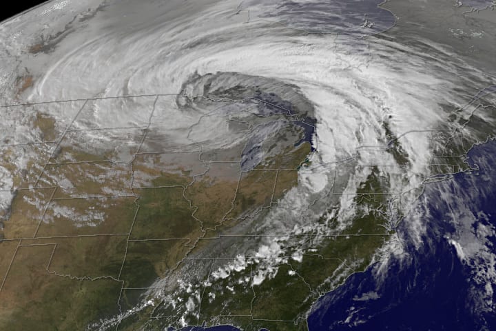
Looking at the visible satellite image I can clearly tell this is not a mature mid-latitude cyclone. It has the potential but the stationary front in the system is the inhibitor. In order for a full mature mid-latitude cyclone to form the the cold air mass needs to over take the warm air mass in in the stationary front.


This is what a mature mid-latitude cyclone looks like (above). Regardless look for vertical growth in the cumulus clouds over the next twelve hours. It is possible that we could see some thunderstorms this evening and early tomorrow morning. I have a feeling we could in for a good storm tomorrow afternoon as well, more on that tomorrow though!


Monday, April 16, 2012

Current Weather Conditions for Monday April 16th, 2012

Current Conditions
Temperature - 38 degrees Fahrenheit
Dew point - 29 degrees Fahrenheit
Wind direction - W
Wind speed - 11 mph
Barometric pressure - 1029.94 g/kg
Cloud cover - Overcast (Stratus)

I had to correct my friend this morning, that it was not snowing. What he thought was snow was actually graupel. So for those of you who were thinking--snow in April, this really blows! Not so it was graupel, although I will admit the walk to school was not the most pleasant. More than anything I am most ticked about the weather's probable affect on Wisconsin's fruit tree crop for this year. Anyways let's check out the weather for today in Eau Claire. I would also like to touch on the affect the warm, relatively dry winter had on states in the Western U.S.


I am bringing you all a new 300mb today, courtesy of intellicast.com. As you can see the jet-stream is really dipping down into the southern U.S. You would think temperatures would be a bit warmer presently in Wisconsin because of this.


However, Wisconsin's general wind direction is still being influenced by the low pressure system we saw the worst from last night. The colder air being drawn from Canada is why temperatures are rather cold today. Over the course of tonight and tomorrow morning, the high pressure system to the northwest of us will begin displacing the low pressure system.


This is a forecast surface map for tomorrow afternoon. As you can see the low pressure system has been pushed farther northeast and the high pressure system, which is currently northeast of us, is predicted to settle almost on top of Eau Claire. Take of the predicted dryline to the northwest of Eau Claire on this map. This could potentially cause some thunderstorms in the late afternoon and early evening tomorrow. As an overall trend this week expect warmer temperatures than today and clearing cloud conditions as the week progresses.

While Wisconsin continues to have a possible fruit tree disaster...Colorado and other States in the Western U.S. have a pressing issue at hand.

http://www.accuweather.com/en/weather-news/low-colorado-snow-pack-could-p-1/64120

Please read the article posted above if you have the time, it is a very ineresting read. While Europe was absolutely obliterated with snowfall this winter, Colorado, did not see near as much as normal. Not only did a less than desirable snowpack in the eyes of skiiers hurt the winter sports economy in Colorado, now Colorado is facing the issue of a water shortage.

Sunday, April 15, 2012

Current Weather Conditions for April 15th, 2012

Current Conditions
Temperature - 63 degrees Fahrenheit
Dew point - 60 degrees Fahrenheit
Wind speed - 3 mph
Wind direction - E
Barometric Pressure - 1029.34 g/kg
Cloud cover - Overcast

Wow am I screwing up or what? I am out of town and I am missing what could possibly be a thunderstorm in Eau Claire. Sorry folks, I am going to have to remotely report on this one.


Let's get down to it. As you can see there is a lot of precipitation in the United States currently. The low pressure system on the eastern edge of Minnesota is drawing all of this moisture up from the Gulf of Mexico.


Presently the upper air sounding for Minneapolis shows us that conditions are stable according to the LI and KI values, despite some capping inversion. So Minneapolis is basically looking at some rain showers in the near future. But what about the possibility of thunderstorms later on today? There is definitely a chance that Eau Claire will see thunderstorms. I would really like to be in Eau Claire to see what is going on in terms of cloud type. Remember, if it is cumulus cloud cover look for vertical growth.

Thursday, April 12, 2012

Current Weather Conditions for Thursday April 12th, 2012

Current Conditions
Temperature - 54 degrees Fahrenheit
Dew point - 20 degrees Fahrenheit
Wind direction - NW
Wind speed - 3 mph
Barometric pressure - 1030.11 g/kg
Cloud cover - clear


The National Oceanic and Atmospheric Administration recently put out the temperature data for March, take a look! Washington was the only contiguous U.S. state that had below average temperature for the month of March. Oregon and and California were near normal, otherwise every other contiguous state experienced above normal temperatures.

This morning we saw frost for the third morning in a row as I had predicted. Fortunately I believe we are safe from freezing conditions tomorrow and throught the weekend.

Legend


Let's take a look at what the weather is going to look like moving into tonight and tomorrow morning in the Eau Claire area.


Currently the high pressure system over Michigan is producing a NW wind direction in Eau Claire. However look to the west of Wisconsin at the rain being producing along that occluded front. As the low pressure system moves east expect the wind direction to gradually shift to a SE orientation in the Eau Claire area. Sometime in the the 10 am to 11 am time frame tomorrow I expect we will see rain, which the plains states are currently experiencing.

Wednesday, April 11, 2012

Current Weather Conditions for Wednesday April 11th, 2012

Current Conditions
Temperature - 51 degrees Fahrenheit
Dew point - 22 degrees F
Wind direction - NNE
Wind speed - 3 mph, gusting up to 7 mph
Barometric pressure - 1030.22 g/kg
Cloud cover - clear

This is one forecast that I can say, I really wish I wasn't right about. Eau Claire did indeed see freezing temperatures and some frost overnight. The low in Eau Claire hit around 26 degrees F, which is not good news for fruit trees and a lot of other vegetation already in bloom. If your apple trees at home have already blossomed, temperatures below 27 degrees Fahrenheit can kill them. Severe frost can also do your apple blossoms in, although the blossoms may look fine the pistil (center tenticle like thing of the blossom) is likely dead. All of the apple trees I have seen in Eau Claire have already blossomed. However if your apple trees are still just budding, you're crop is likely unharmed as they can tolerate temperatures down to 24 degrees Fahrenheit. Since the temperature did not get drop terribly far beneath 27 degrees Fahrenheit the blossoms on the branches higher up on the tree are likely still healthy. But are we in the clear or we in store for another cold snap overnight?

Legend


Once again we are under a freeze warning into tomorrow morning. So we'll take a look at what is going to possibly cause freezing conditions overnight in today's post. Hold on, what is up with the tornado watch in the area where New Mexico, Northern Texas, Colorado, and Oklahoma all touch? Let's take a peak at that too.


I am introducing a new map to you all today, this is a 925 mb surface map. It does a nice job of conveying what general wind speed and direction looks like relatively close to the surface. In regards to the current weather conditions in Eau Claire it is evident that high pressure system you see in the first surface map is moving colder winds from Canada down into Wisconsin and Illinois. This is why clound conditions are so clear today, but this is also why we are at risk for frost overnight. Looking at both surface maps you can easily see the low pressure system southeast of the Rockies and the high pressure system east of Texas. These pressure systems are key in the development of these tornadoes, however the high pressure system over Illinois is also important. What is going on the low pressure system is drawing cold dry air over the leeward side of the Rockies, while the high the pressure system east of Texas is bringing warm moist air through Texas from the Gulf of Mexico. Meanwhile the high pressure center over Illinois is moving cold air from the NE, causing convergence with the warm air from the high pressure system east of Texas. Now what this has formed is a dry line. Remember we talked about dry lines yesterday? The convergence of the warm air and cold air from the high pressure system has created temperatures similar to those produced by the low pressure system. The difference is that the low pressure system has produced very dry air, while the converging air from the high pressure systems is moist. But let's take a look at upper atmosphere sounding and see just how unstable the atmosphere is.


Pretty darn unstable...KI of 34 and an LI of  -3.5, so thunderstorms are just about a 100 percent chance. I will keep you posted on tornadoes in the SW and frost dangers here at home.