Sunday, April 29, 2012

Current Weather Conditions for Sunday April 29th, 2012

Current Conditions
Temperature - 57.6 degrees Fahrenheit
Dew point - 31 degrees Fahrenheit
Relative humidity - 36%
Wind direction - SE (http://hint.fm/wind/index.html)
Wind speed - 4 mph
Barometric pressure - 1030.08 g/kg
Cloud cover - overcast (altostratus)

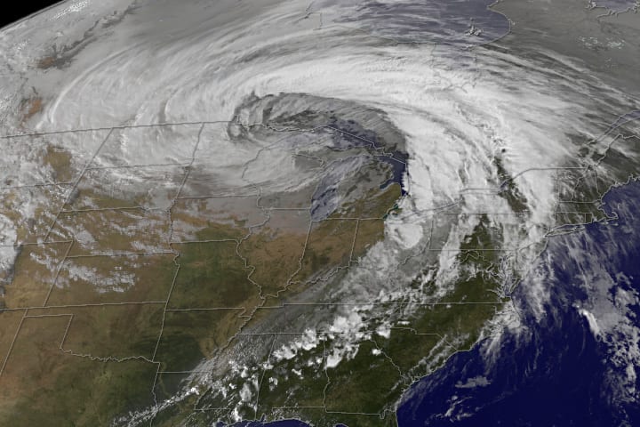
Happy Sunday everybody, if you haven't noticed yet I am going to be using the wind map that I have been posting next to the wind direction under the current conditions section. So if you want to get the full experience out of my posts please look at it before you read any further.


We actually have some interesting weather patterns today, so let's get to it. Notice the rain currently falling over mostly over Missouri, Illinois, and Iowa to the north of the stationary front. I am sure if you looked at the wind map today you noticed the winds northward from the Gulf of Mexico. What is happening is those winds are warm moist and conditionally unstable. In order for precipitation to occur the airmass needs a lifting mechanism which is where the cold airmass comes into play and forces itself underneath the warm moist airmass in a process called convective lifting. 

So what does this mean for us? Well essentially that warm front is going to take over the cold front and begin moving in a northerly direction and as the low pressure system over New Mexico dies out a cold front from the Rockies will move across the Great Plains. These conditions are what will cause the formation of a mid-latitude cyclone. Guess what it is headed for the upper Midwest too! So as for tomorrow expect cloudy skies, some rain off and on, and temperatures similar to todays. Once the mid-latitude cyclone develops more the Eau Claire area will likely experience thunderstorms and temperatures in the mid-70's beginning on Tuesday.


Friday, April 27, 2012

Current Weather Conditions for Friday April 27th, 2012

Current Conditions
Temperature - 53.8 degrees Fahrenheit
Dew point - 19 degrees Fahrenheit
Relative humidity - 24%
Wind direction - SE (http://hint.fm/wind/index.html)
Wind speed - 6 mph, gusting up to 11 mph
Barometric pressure - 1030.11 g/kg
Cloud cover - clear


We have some really cool weather patterns to look at today in the United States. The Eau Claire area is not so exciting however so we will only spend a little time talking about it. I hope you all checked out the wind map today, if you had trouble viewing it I recommend that you use Google chrome as your browser. Notice the dry line running between the low pressure symbol on the border of Canada and the low pressure symbol over Wyoming. There is also a fair amount of rainfall being produced by the stationary front in the southern United States. What is most interesting about the weather today is the mid-latitude cyclone over Nebraska that is in its developing stage. As you can see in the image below.


My prediction for the course of this storm may differ slightly from what you have seen on the weather channel. As this system progresses I don't foresee the Eau Claire area receiving much rainfall if any at all, which differs from the weekend forecast on weather.com. What I think will likely happen in the mid-latitude cyclone will break off from the area where that dry line is currently. While the the mid-latitude cyclone is going to track towards Florida. A lot of forecasts predict showers in the Eau Claire area tomorrow due to the low pressure system below the dry line. However I predict it will just miss us and move across South West Wisconsin. 

Wednesday, April 25, 2012

Current Weather Conditions for Wednesday April 25th, 2012

Current Conditions
Temperature -51.3 degrees Fahrenheit
Dew point - 45 degrees Fahrenheit
Relative humidity - 79%
Wind direction - SE, http://hint.fm/wind/index.html (Check out the link to see the mid-latitude cyclone over Wisconsin currently, I recommend using Google Chrome as your browser!) 
Wind speed - 4 mph, gusting up to 7 mph
Barometric pressure - 1029.66 g/kg
Cloud cover - overcast

The Eau Claire area along with much of Minnesota and other parts of Wisconsin has experienced rainfall, however the system I was talking about yesterday has not proved particularly fearsome.


The atmosphere is unstable in the Minneapolis area as indicated by the KI value and the orientation of the environmental lapse rate to the left of the DAR and MAR on the SKEW T graph. That said, rainfall amount from 2 am up until now (12:20pm) is under 0.25 inches. I don't expect the Eau Claire area will see anything more than another quarter of an inch from this system. Let's take a look at why that is.


If you took a look at the wind map I posted under the current conditions you can see the movement of the mid-latitude cyclone in the area very well. It is very difficult to make it on this satellite water vapor image. This is due to the lack of moisture in the system, something I didn't fully expect. However what I do expect is for the storm to strengthen.


By observing the course of today's jet-stream on the 300 millibar map it allows us to gain a general understanding of how this mid-latitude cyclone will track. In this case the storm will track over the southeast United States. As this storm moves farther south the low pressure system will draw up more warm moist air, which in affect will strengthen the storm and cause an increase in rainfall.

Tuesday, April 24, 2012

Current Weather Conditions for Tuesday April 24th, 2012

Current Conditions
Temperature - 67 degrees Fahrenheit
Dew point - 30 degrees Fahrenheit
Relative humidity - 26%
Wind direction -n/a (calm) http://hint.fm/wind/index.html (I recommend you use Google chrome, really cool!)
Wind speed - 0 mph
Barometric pressure - 1029.56 g/kg
Cloud cover - clear


Told you guys, the weather was going to be boring in Eau Claire. But it is quiz time for all of you, without looking at the surface map below, tell me what the water vapor formation over New England is called and what type of front is over Missouri, Nebraska, Kansas, and South Dakota. First person to answer correctly in the comments section gets a cookie (seriously I will mail to you if I have to).


If your answers were mid-latitude cyclone and stationary front you are correct! Notice the mid-latitude cyclone is in its dying stages as is indicated by the occluded front. I am sure that many New Englanders are glad to receive that bit of news. Let's shift our attention to the stationary front. Moving into tonight I predict that the warm front will take over the cold front as the cold front in the Northwest U.S. does the same. What this will cause is the development of another mid -latitude cyclone. While this system could produce thunderstorms as early as tonight. I am willing to bet that we won't see thunderstorms in the Eau Claire area until early tomorrow morning due the time necessary for this mid-latitude cyclone to mature.

Monday, April 23, 2012

Current Weather Conditions for Monday April 23rd, 2012

Current Conditions
Temperature - 58 degrees Fahrenheit
Dew point - 33 degrees Fahrenheit
Relative humidity - 38%
Wind direction - NW
Wind speed - 3 mph, gusting up to 7 mph.
Barometric pressure - 1029.95 g/kg
Cloud cover - scattered (cumulis humulis)


Let's jump right into it today. The high pressure system over New England is currently producing the relatively clear cloud conditions and NW winds in the Eau Claire area.


However as that high pressure system moves farther east over the Atlantic ocean, Eau Claire will likely see a shift in wind direction. The wind direction will likely shift to coming from a more easterly orientation. If you look at the photo I took just a few minutes ago you can see there is already some change in direction in the upper atmosphere as is indicated by the straiation in the cumulus humilis cloud.

Honestly weather in the Eau Claire area is going to be pretty ridulously boring tomorrow. Expect slightly warmer temperatures than today and thicker cloud cover. New England is getting drenched on pretty bad so let's check that out.


Pretty cool variety of weather alerts for the Northeast U.S., even some winter weather alerts for some areas on the south shore of Lake Erie.


Looking at the 12 hr forecast surface map above and observing how the storm will track it becomes clear that those areas under winter weather advisory could very likely see some lake enhanced snowfall. Let me explain what will be causing the current storm to strengthen over the course of today and into tomorrow morning. Where you see the low pressure system on the map the cold front is wedging under the warm moist conditionally unstable airmass associated with the warm front on the map.

I'll talk about this more tomorrow. Until then do some storm tracking of your own if you have the time and don't be afraid to leave comments on my posts people!


Saturday, April 21, 2012

Current weather Conditions for Saturday April 21st, 2012

Current Conditions
Temperature - 50.8 degrees Fahrenheit
Dew point - 29 degrees Fahrenheit
Relative humidity - 43%
Wind speed - 3 mph, gusting up to 6 mph.
Wind direction - E
Barometric pressure - 1029.87 g/kg
Cloud cover - overcast (stratus)


As I had predicted in yesterday's post, cloud cover has returned this evening after nice clear conditions throughout the morning. Take a look at where the mid-latitude cyclone, which I referenced in yesterday's post, is currently.


Looking at the water vapor satellite image you can just barely see the mid-latitude cylclone. However is the series of low pressure systems that came through Wisconsin and many other states, just a few day ago, is quite evident over the Eastern sea-board.


Although this mid-latitude cyclone is not very strong we will still some rainshowers, very soon I expect. Currently temperatures are similar in the airmasses west and east of the mid-latitude cyclone, however the airmass to the west has a higher moisture content. As we have covered previously, this is known as a dryline and is the reason for the precipitation that will occur within the next hour. As for tomorrow morning the Eau Claire area could still be experiencing rainshowers. From late afternoon on cloud cover will begin to clear however.

Friday, April 20, 2012

Current Weather Conditions for Friday April, 2012

Current Conditions
Temperature - 53.9 degrees Fahrenheit
Dew point - 22 degrees Fahrenheit
Relative humidity - 29 %
Wind direction - ENE
Wind speed - 3 mph
Barometric Pressure - 1029.94 g/kg
Cloud cover - clear


If you look at the surface map you can see the three low pressure systems I talked about yesterday have moved to the east of us today. The cold front associated with these low pressure systems is currently wedging itself under the warm moist unstable air mass from the Gulf of Mexico, which is causing precipitation. Also make note of the mid-latitide cyclone forming over Montana, which is also causing precipitation.

Visible Water Vapor - US Current

Here is a water vapor satellite image to give you a better idea of the water content in both of these systems. Over tonight expect a continutation of clear skies and a temperature drop to approximately 30 degrees Fahrenheit. By tomorrow evening expect overcast skies followed by a rainshowers produced by the mid latitude cyclone currently over Montana.

Thursday, April 19, 2012

Current Weather Conditions for Thursday April 19th, 2012

Current Conditions
Temperature - 43 degrees Fahrenheit
Windchill - 38 degrees Fahrenheit
Dew Point - 33 degrees Fahrenheit
Relative humidity - 66%
Wind direction - Shifting between E and ENE
Wind speed - 4 mph, gusting up to 9 mph
Barometric pressure - 1029.92 g/kg
Cloud cover - Overcast (altostratus)

A brief rainshower occurred in the Eau Claire area this morning between 8 am and 9 am. Since then clouds have held off on the precipitation. I assure you though, more scattered rainshowers are on the way.

UA Mandatory Level - 300 mb -12 hr

I would like to point out the very zonal flow pattern of the jetstream today. Zonal flows means that the jetstream is very horizontal. The jet stream three days ago was a good example of meridional flow pattern (below).

UA Mandatory Level - 300 mb -72 hr


The three low pressure systems depicted on the surface map are drawing up moist warm air from the Gulf of Mexico. These low pressure systems in conjunction with the high pressure system above Wisconsin producing a cold front is causing rain showers. Specifically the the warm air is replacing the cold air by sliding over the top of the cold front.


Wednesday, April 18, 2012

Current Weather Conditions for Wednesday April 18th, 2012

Current Conditions
Temperature - 64 degrees Fahrenheit
Dew point - 43 degrees Fahrenheit
Wind direction - W
Wind speed - 12 mph
Barometric pressure - 1029.77 g/kg

Eau Claire indeed played host to a mature mid-latitude cyclone last night, which brought thunderstorms that produced 0.5 inches of rain. While the sky cleared up considerably today more rain is still on the way.


You can see the low pressure system from last night is in its dying phase, as is evident by the occluded front over Lake Superior. This low pressure system is still producing some rains however Northeast of Canada. What we are in store for is the precipitation associated with that stationary front over Montana. Expect showers of and on beginning around 7 am tomorrow and continuing throughout the evening.

Tuesday, April 17, 2012

Current Weather Conditions for Tuesday April 17th, 2012

Current Conditions
Temperature - 51 degrees Fahrenheit
Dew point - 32 degrees Fahrenheit
Wind direction - SW
Wind speed - 1 mph
Barometric Pressure - 1030.21 g/kg
Cloud cover - broken (cumulus humilus)

Around 7 or 8 o'clock morning, the high pressure system, I had predicted would move over the Eau Claire area did just that. You may have noticed calm winds this morning, this was due to the high pressure system's center being directly over Eau Claire. The nature of the high pressure system pushing wind outward in a clockwise orientation is the specific reason for this.


The surface map is currently depicting the center of the high pressure system has moved to the eastern edge of Wisconsin. I see a few dry lines on the surface map, but what else is there of note on this map? How about the low pressure system to our West? But is it a developing mid-latitude cyclone and how soon before that low pressure system is knocking on our doorstep?


Looking at the visible satellite image I can clearly tell this is not a mature mid-latitude cyclone. It has the potential but the stationary front in the system is the inhibitor. In order for a full mature mid-latitude cyclone to form the the cold air mass needs to over take the warm air mass in in the stationary front.


This is what a mature mid-latitude cyclone looks like (above). Regardless look for vertical growth in the cumulus clouds over the next twelve hours. It is possible that we could see some thunderstorms this evening and early tomorrow morning. I have a feeling we could in for a good storm tomorrow afternoon as well, more on that tomorrow though!


Monday, April 16, 2012

Current Weather Conditions for Monday April 16th, 2012

Current Conditions
Temperature - 38 degrees Fahrenheit
Dew point - 29 degrees Fahrenheit
Wind direction - W
Wind speed - 11 mph
Barometric pressure - 1029.94 g/kg
Cloud cover - Overcast (Stratus)

I had to correct my friend this morning, that it was not snowing. What he thought was snow was actually graupel. So for those of you who were thinking--snow in April, this really blows! Not so it was graupel, although I will admit the walk to school was not the most pleasant. More than anything I am most ticked about the weather's probable affect on Wisconsin's fruit tree crop for this year. Anyways let's check out the weather for today in Eau Claire. I would also like to touch on the affect the warm, relatively dry winter had on states in the Western U.S.


I am bringing you all a new 300mb today, courtesy of intellicast.com. As you can see the jet-stream is really dipping down into the southern U.S. You would think temperatures would be a bit warmer presently in Wisconsin because of this.


However, Wisconsin's general wind direction is still being influenced by the low pressure system we saw the worst from last night. The colder air being drawn from Canada is why temperatures are rather cold today. Over the course of tonight and tomorrow morning, the high pressure system to the northwest of us will begin displacing the low pressure system.


This is a forecast surface map for tomorrow afternoon. As you can see the low pressure system has been pushed farther northeast and the high pressure system, which is currently northeast of us, is predicted to settle almost on top of Eau Claire. Take of the predicted dryline to the northwest of Eau Claire on this map. This could potentially cause some thunderstorms in the late afternoon and early evening tomorrow. As an overall trend this week expect warmer temperatures than today and clearing cloud conditions as the week progresses.

While Wisconsin continues to have a possible fruit tree disaster...Colorado and other States in the Western U.S. have a pressing issue at hand.

http://www.accuweather.com/en/weather-news/low-colorado-snow-pack-could-p-1/64120

Please read the article posted above if you have the time, it is a very ineresting read. While Europe was absolutely obliterated with snowfall this winter, Colorado, did not see near as much as normal. Not only did a less than desirable snowpack in the eyes of skiiers hurt the winter sports economy in Colorado, now Colorado is facing the issue of a water shortage.

Sunday, April 15, 2012

Current Weather Conditions for April 15th, 2012

Current Conditions
Temperature - 63 degrees Fahrenheit
Dew point - 60 degrees Fahrenheit
Wind speed - 3 mph
Wind direction - E
Barometric Pressure - 1029.34 g/kg
Cloud cover - Overcast

Wow am I screwing up or what? I am out of town and I am missing what could possibly be a thunderstorm in Eau Claire. Sorry folks, I am going to have to remotely report on this one.


Let's get down to it. As you can see there is a lot of precipitation in the United States currently. The low pressure system on the eastern edge of Minnesota is drawing all of this moisture up from the Gulf of Mexico.


Presently the upper air sounding for Minneapolis shows us that conditions are stable according to the LI and KI values, despite some capping inversion. So Minneapolis is basically looking at some rain showers in the near future. But what about the possibility of thunderstorms later on today? There is definitely a chance that Eau Claire will see thunderstorms. I would really like to be in Eau Claire to see what is going on in terms of cloud type. Remember, if it is cumulus cloud cover look for vertical growth.

Thursday, April 12, 2012

Current Weather Conditions for Thursday April 12th, 2012

Current Conditions
Temperature - 54 degrees Fahrenheit
Dew point - 20 degrees Fahrenheit
Wind direction - NW
Wind speed - 3 mph
Barometric pressure - 1030.11 g/kg
Cloud cover - clear


The National Oceanic and Atmospheric Administration recently put out the temperature data for March, take a look! Washington was the only contiguous U.S. state that had below average temperature for the month of March. Oregon and and California were near normal, otherwise every other contiguous state experienced above normal temperatures.

This morning we saw frost for the third morning in a row as I had predicted. Fortunately I believe we are safe from freezing conditions tomorrow and throught the weekend.

Legend


Let's take a look at what the weather is going to look like moving into tonight and tomorrow morning in the Eau Claire area.


Currently the high pressure system over Michigan is producing a NW wind direction in Eau Claire. However look to the west of Wisconsin at the rain being producing along that occluded front. As the low pressure system moves east expect the wind direction to gradually shift to a SE orientation in the Eau Claire area. Sometime in the the 10 am to 11 am time frame tomorrow I expect we will see rain, which the plains states are currently experiencing.

Wednesday, April 11, 2012

Current Weather Conditions for Wednesday April 11th, 2012

Current Conditions
Temperature - 51 degrees Fahrenheit
Dew point - 22 degrees F
Wind direction - NNE
Wind speed - 3 mph, gusting up to 7 mph
Barometric pressure - 1030.22 g/kg
Cloud cover - clear

This is one forecast that I can say, I really wish I wasn't right about. Eau Claire did indeed see freezing temperatures and some frost overnight. The low in Eau Claire hit around 26 degrees F, which is not good news for fruit trees and a lot of other vegetation already in bloom. If your apple trees at home have already blossomed, temperatures below 27 degrees Fahrenheit can kill them. Severe frost can also do your apple blossoms in, although the blossoms may look fine the pistil (center tenticle like thing of the blossom) is likely dead. All of the apple trees I have seen in Eau Claire have already blossomed. However if your apple trees are still just budding, you're crop is likely unharmed as they can tolerate temperatures down to 24 degrees Fahrenheit. Since the temperature did not get drop terribly far beneath 27 degrees Fahrenheit the blossoms on the branches higher up on the tree are likely still healthy. But are we in the clear or we in store for another cold snap overnight?

Legend


Once again we are under a freeze warning into tomorrow morning. So we'll take a look at what is going to possibly cause freezing conditions overnight in today's post. Hold on, what is up with the tornado watch in the area where New Mexico, Northern Texas, Colorado, and Oklahoma all touch? Let's take a peak at that too.


I am introducing a new map to you all today, this is a 925 mb surface map. It does a nice job of conveying what general wind speed and direction looks like relatively close to the surface. In regards to the current weather conditions in Eau Claire it is evident that high pressure system you see in the first surface map is moving colder winds from Canada down into Wisconsin and Illinois. This is why clound conditions are so clear today, but this is also why we are at risk for frost overnight. Looking at both surface maps you can easily see the low pressure system southeast of the Rockies and the high pressure system east of Texas. These pressure systems are key in the development of these tornadoes, however the high pressure system over Illinois is also important. What is going on the low pressure system is drawing cold dry air over the leeward side of the Rockies, while the high the pressure system east of Texas is bringing warm moist air through Texas from the Gulf of Mexico. Meanwhile the high pressure center over Illinois is moving cold air from the NE, causing convergence with the warm air from the high pressure system east of Texas. Now what this has formed is a dry line. Remember we talked about dry lines yesterday? The convergence of the warm air and cold air from the high pressure system has created temperatures similar to those produced by the low pressure system. The difference is that the low pressure system has produced very dry air, while the converging air from the high pressure systems is moist. But let's take a look at upper atmosphere sounding and see just how unstable the atmosphere is.


Pretty darn unstable...KI of 34 and an LI of  -3.5, so thunderstorms are just about a 100 percent chance. I will keep you posted on tornadoes in the SW and frost dangers here at home.

Tuesday, April 10, 2012

Eastern U.S. Forest Fires

Fire Weather Continues in the East

Current Weather Conditions for Tuesday April 10th, 2012

Current Conditions
Temperature - 38 degrees Fahrenheit
Wind chill - 31 degrees F
Dew point - 13 degrees F
Wind direction - NE
Wind speed - 6 mph
Barometric pressure - 1030.11 g/kg
Cloud cover - broken (cumulus humilis)

I have big post for you folks today so let's get moving. Let's kick things off with a link -- relating to the unseasonably warm March we had -- that I would like you all to check out.

http://www.accuweather.com/en/weather-news/noaa-release-unprecedented-mar/63833

Next let's take a peak at a surface map for today and an upper air mass map as well.


Before I address conditions in the Eau Claire area, I want to familiarize you all a bit more with surface maps. Today's topic is the dryline, which is the dashed brown line you have seen in maps I have posted in the past. The dryline depicts the converging boundaries of two airmasses with radically different in moisture content but with very little difference in temperature. Look at the map and you'll notice a dry line on the eastern side of Arizona, extending down into Mexico. Dry lines in this area and just east of the Rocky Mountains are common, due to warm dry air descending over the leeward side of mountains and warm moist air being drawn northward by a low pressure system. Dry lines often cause precipitation, which is exactly what is happening in New England today. As for Eau Claire, well we have another issue to worry about.

UA Mandatory Level - 300 mb Current

As you can see the jet stream moving right over Eau Claire today. This is what explains the colder temperatures and high wind speeds again today. As was the case yesterday, we have to worry about freezing overnight. Tonight and early tomorrow morning will actually be a bigger threat than last night and this morning. I know what your thinking, it was indeed colder and windier yesterday. When it comes to frost, wind is actually our friend because is doesn't allow for cold air to sink to the ground developing frost. If wind speeds continue to die down overnight we are in trouble. Here are the current projections for tomorrow.

Legend


I personally think that we will see some frost tomorrow morning. However I predict that we will have clear skies tomorrow and hopefully the sun will be able to burn off the frost quickly.

Monday, April 9, 2012

Current Weather Conditions for Monday April 9th, 2012

Current Conditions
Temperature - 43 degrees Fahrenheit
Wind Direction - WNW
Wind Speed - 20 mph and gusting up to 25 mph.
Barometric Pressure - 1030.07 g/kg
Cloud Cover - Overcast

Sorry my little hiatus the past couple days, I was up north at my cabin again and didn't have any internet access. Hope you all had a great weekend whether you were visiting family for Easter or not. Let's get right down to business though. I am sure most of you have noticed how strong winds have been today, but what is causing them?


Yeah the map is busy, but it does a great job at depicting cloud cover, wind speed, wind direction, fronts, and pressure systems all at once. What I would like you to take from this surface map is the high pressure system centered over Montana and the low pressure system in southern Michigan. Looking at our current barometric pressure reading of 1030.07 g/kg it is pretty evident that we are under the affect of the high pressure system. Well then why is there overcast skies, you may be wondering? We are in fact right in the middle of these two pressure systems converging, which explains the cloud cover. The mixing of these two pressure systems is also what is causing the gusting winds.

Cooler temperatures than we experienced in March seem to remain the trend in April thus far. As you can see the jet stream is very defined and relatively horizontal in orientation over the northern U.S., causing high speeds.


While we have had an unusually warm spring in Wisconsin so far, it is only early April and we are by no means in the clear in regards to cold-snap risk. Therefore I will continue to keep a close eye on frost risk for you all.


As you can see projections for temperatures below 32 degrees F and frost risk don't bode well for the Northern U.S. It is rather interesting how similar the jet stream for today and at risk areas for tomorrow morning look.


Thursday, April 5, 2012

Current Weather Conditions for Thursday April 5th, 2012

Current Conditions
Temperature - 43 degrees F
Wind Direction - NE
Wind Speed - 4 mph
Barometric Pressure - 1030.08 g/kg
Cloud Cover - clear

I wasn't lying to you guys yesterday, the weather patterns were indeed boring. Conditions remained very similar today as yesterdays. In today's post there is some important weather I would like to cover.


As you can we again have a high pressure system to the north of Wisconsin centered over Canada. This is what is causing clear conditions and NE winds. These high pressure systems over Canada have caused cooler temperatures than the low pressure systems drawing up warmer air from the south we saw during much of March.


During March the jet-stream was well north of Wisconsin, which allowed for warmer winds to push into the upper Midwest. Remember back to the prior posts when I expressed my concern over the unseasonably warm spring and the affect it would have on early blooming vegetation. Well now that temperatures are cooling down closer to average temperature we could be in serious cold-snap danger.


Tonight temperatures will likely fall beneath 32 degrees F. It is a pretty safe bet this will happen because any heat that was absorbs by the earth's surface will be allowed to escape due to the lack of cloud cover. As you can see on the map above just a very small portion of Wisconsin, west of Eau Claire, is projected to have frost accumulation. Regardless Eau Claire may see frost and if not cold weather could still spell trouble.

Wednesday, April 4, 2012

Current Weather Conditions for Wednesday April 4, 2012

Current Conditions
Temperature - 59 degrees Fahrenheit
Wind Direction - NE
Wind Speed - 9 mph
Barometric Pressure - 1029.91 g/kg
Cloud Cover - Clear (some cirrus clouds)

As I had expected a sunny day, relatively warm in regards to recent temperatures, and cooler winds due to a high pressure system to the north of us in Canada. First of let's take a look at the jet stream today.


The jet stream is pretty funky today, it's dipping way down into southern California. Earlier today it was as far south as Arizona. Honestly the weather in Eau Claire today is pretty boring and will continue to be boring throughout tomorrow. As this high pressure system continues to move east the wind direction will shift to due East and clear skies stick around.


Tuesday, April 3, 2012

Current Weather Conditions for Tuesday April 3rd, 2012

Current Conditions
Temperature - 50 degrees F
Wind Direction - ENE
Wind Speed - 7 mph
Barometric Pressure - 1029.95 g/kg
Cloud Cover - Overcast (status, stratocumulus)

I know you are all wondering where the clearing conditions and warm weather I called for is. Have a little faith in me, I predicted that thunderstorm last night didn't I? I promise the sun will peak out soon.

Surface Data - US Current

The pressure system that caused last night thunderstorm is currently centered in the very Southwest corner of Wisconsin. Yesterday we were on the leading right edge of the low pressure system, which caused ESE winds. Currently we are on the backside of the low pressure system, which is causing the NE winds today. Look to the West of Eau Claire into Minnesota, the circle at the base of the weather barbs are not filled in. This means clear skies and is being caused by the high pressure system. Here is a better look below.

Surface Data - Midwest Current

I am inclined to think that skies will begin clearing somewhere in the 2:30 pm to 4 pm window and skies will be mostly clear by 7pm tonight. Along with clearing skies temperatures will rise slightly, however they will not reach the high I predicted for today due late clearing. Overnight expect wind direction to shift as well, first to due North and then to due East over the course of tomorrow. Despite clear conditions tomorrow, temperatures will be cooler than today or yesterday due to the high pressure system that will move in and whip cool winds from Canada into Wisconsin. Expect mid to upper 50's (F) for the high.